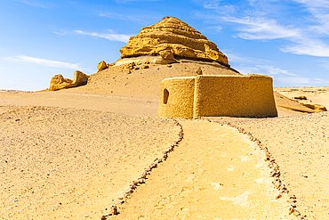
Mudawara Mountain, where stargazing and camping are few options
Only 90 km from the capital city of Cairo, an hour and 15 minutes drive, with a year round moderate weather, is one of Egypt’s 7 oases, Al Fayoum.
Home to several attractions from different eras from Pharaonic, Greco-Roman, Coptic and Islamic, to sand dunes, palm trees, lakes and valleys, wild animals, bird species. It’s a land of unspoiled nature & rich history, a place worth discovering.
Within the area, are a number of lakes, Egypt’s only permanent waterfall, and the unusual Mudawara Mountain (Jebel al- Mudawara), located to the west of Al Fayoum Lake.
Mudawara Mountain is located only a couple of hundred meters to the south of Wadi El Rayyan Road, just after it passes to the north of Al Fayyum Lake. You can park at the edge of the road, or some people actually drive across the desert to the base of the formation.
The mountain has three main summits with a few bumps rising to the west. The easternmost is a short spire of rock with a surprising pit dug into the summit. It has a small enough footprint that Google Earth doesn’t even register its presence. Interestingly, it is the hardest summit to reach and most likely has a top below sea level.
Mudawara Mountain, 45 million years old, is associated with the pre-Middle Leocene period, which moved north of Egypt, resulting in arches in the north-east and south-west direction.
The mountain is characterized by a spectacular view and an open location, with the spread of the so-called “angel pits”, which resemble the fossilized coins in the region. The surface of the area is characterized by a refractive fracture and was filled with water as part of a vast lake, “At the end of the Pleistocene period – one of the geological ages – where the lake began to dry sequentially, gradually.
Leave a Reply